CLASSIC PROVENCE: THE LUBÉRON MOUNTAINS
1. LOURMARIN TO BONNIEUX
2. BONNIEUX TO SÉGUIN and SÉGUIN TO BONNIEUX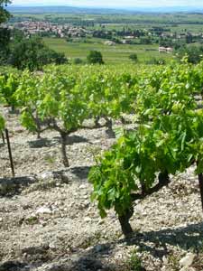
3. SÉGUIN – BUOUX RING WALK
4. SÉGUIN – SIVERGUES RING WALK
5. VAUGINES TWO-DAY RING WALK, via Fort de Buoux, Séguin, Sivergues and le Castelas
6. GORDES – ABBAYE DE SÉNANQUE RING WALK
7. OPPÈDE LE VIEUX RING WALK
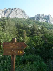
WINE AND LACE: GIGONDAS AND THE DENTELLES
8. SÉGURET RING WALK
(01/2014) In Provence, we stayed in a tiny hamlet, Les Alazards with lots of local walks – the nearest shop is in Malucene 6 kms away. It was near the great Rhone wine areas. Your book was invaluable! We did the Seguret Ring Walk – all directions clear. We took far longer and found the final “quite steep downhill track” quite challenging for our late 60s knees and ankles. But we managed, and now know our outer limit. The next day we took a leisurely walk along the Route du Vignerons in Vacqueras , all flat and passing through various Caves. We also enjoyed a good lunch in Gigondas.
– Peter and Jacqui Robinson
(03/13) Just did the Seguret ring walk. We did it backwards, as we had walked up to Seguret from Sablet and wanted to cut back to Sablet on the return leg. With map 24000 scale, no problems. However, please note that all Seguret restaurants are closed Weds. At least this time of year, end of March.
– Sue Thompson
9. SÉGURET TO GIGONDAS
10. GIGONDAS RING WALK
(03/13) -A note on the Gigondas ring walk: point C no longer has a way mark. The post is there but the sign is gone. Also, In wet weather,like the past few days, the last half of the route has some very muddy and slippery spots, caution recommended going downhill especially.
Thanks for your research and work, we found your instructions easy to follow and navigate with.
Had a great walk.
– Sue Thompson
(09/09) – We have just returned from a wonderful walking holiday in Provence, using your excellent book. We did four walks and found that our time matched yours almost precisely.
We did have two minor comments that might help others on Walk Ten, the Gigondas Ring Walk. Between E and F you mention the Col de Cayron way mark. Right at this point, there is a well marked continuation of the path straight ahead, with plenty of visible blue. The downhill turn to the left is tempting, but there is no blue mark in sight. If you follow the blue straight ahead, you come back up to the top and over to the other side of the valley. We turned back and took the left-hand downhill at the waymark, and found the blue (and the carpark) before very long.
Also, between H and I, you mention a fork uphill right, just above a view over a vineyard. The fork is actually left, but as it is to be ignored, it didn’t matter.
We took the turnoff to Les Florets and had a beautiful lunch on the terrace, even though we arrived a little later than planned.
We hope this is helpful to other walkers.
Jane and Ian Morrison
Sydney, Australia
11. SUZETTE RING WALK
(04/2013) At point C, where the directions say to go right 35-40 paces along side of vineyard and then turn left onto wooded path blazed blue, there is a new path. Instead of turning right where the road bends left and walking along the side of the vineyard, from the bend in the road, just look straight ahead for a tree with a blue blaze. The new path starts right there and is well blazed with blue. It goes downhill. The older path, described in the book, comes in from the right, about 2 minutes walk from this blue blazed tree. (One might also add that the path which bends left, that you don’t take) has a large private property sign about 30 meters ahead on the right.)
– Sue Thompson, Seattle
(03/11) – In May of 2010, a few of us took this walk. We were staying at Le Dégoutaud, so that was very convenient! At point A below Suzette, we were looking for a well paved road and walked a good mile past the turnoff, came back up towards town and saw the the beat-up semi-paved road and took it, it was the right one.
There is one big beef with your choice of time versus distance used in the book, that my main walking companion found maddening. With a GPS or pacing device, the method of using time could be and should be eliminated. Also distance between turn points should be both standard and metric. Oh of course the Suzette walk was very good, with the views above town and such. We encountered a Dutch couple then a group of fellow Americans, from around the U.S., painting a scene with Mt. Ventoux, as we descended through the vineyards into town. Malaucène made a good home town for the four days in the area.
Thanks for the book.
– Kurt
[author note] — We didn’t have a GPS. We aren’t in any way professionals, we did the book as a labor of love. We did the best we could, and have had very good responses to our books, this and especially our Tuscany and Umbria book, which was first published in 1997, so has had more time. We did the best we could to estimate the distance or the time. Again, sorry this is not our professional job, though I wish it were!
BANON AND THE LURE
12. BANON TO LIMANS
13. LIMANS TO LARDIERS
14. LARDIERS TO SAUMANE
15. SAUMANE RING WALK
16. SAUMANE TO BANON
17. BANON – VIEUX MONSALIER RING WALK
18. LES TINETTES RING WALK
19. GORGES D’OPPÈDETTE RING WALK
20. VACHÉRES – OPPÈDETTE RING WALK
21. VIENS RING WALK
(03/11) – In May of 2010, a few of us took this walk, along with the Suzette Ring Walk. Viens went well and the view across the valley and of Viens was quite nice, and the town itself was very good to walk through. We saw ONE other person in town and a group of aged men playing boules outside the town wall, before our walk, that’s all. Thanks for the book.
Kurt
A DIP INTO SOUTHWEST PROVENCE
22. CALANQUE DE MORGIOU RING WALK
(09/12) Road to Morgiou still closed today. However, with a reservation, we were able to drive in and park.
Had the bouillabaisse for lunch today at Nautic Bar Restaurant, but the price was 42 euros per person, not 38 euros for 2 people as in your book.
Hope this helps all your readers!
Rick & Annie
23. CASSIS CALANQUES RING WALK via Port-Miou and Calanque d’En vau
24. CEZANNE RING WALK
MIDDLE PROVENCE: VAR AND VERDON
GENERAL COMMENTS
(11/09) – Congratulations on Walking and Eating in Provence. I have a house about 5 Kms from Seillans in the Var and I look forward to following in your footsteps.
I bought your book just before coming out here and my wife and I (plus Westie dog) have just completed the Mons walk in glorious November weather. I have been reading the text about other walks and have one or two comments, which are certainly intended to be constructive:
1. On page 197 you mention that Seillans, Bargeme and Cotignac are suburbanised. I don’t really agree about Seillans, but Bargeme is as unsuburban a place as you could find anywhere. It’s tiny and the highest village in the Var, with glorious walks around it and which you certainly ought to include in your next edition. There is a splendid mountain restaurant, La Gruppie in Chateauvieux too which you can walk from Bargeme. I think you have confused Bargeme with Bargemon, 16 Kms to the south and which could be described as suburbanised.
[author note] — We had a “coffee table” book called “The Most Beautiful Villages in Provence,” or something along those lines, that had all those villages in it. We used that book to plan out (to the loose degree we were able to plan before we actually got there) where we’d go. Most of the villages in that book were not really walkable, because they’d been too suburbanized (or suburbanised, for U.K. readers). The villages you mention are certainly not in the same category as those along the coast and going up the western edge of Provence, which are really ruined for walking. Your email makes me feel that we should’ve taken a closer look and not given up when we saw what appeared to be cascades of houses dropping down the hills from the villages. In any case, if we get a chance to go back, we will definitely take a closer look at these villages.
2. On page 200, you mention that the Sentier Martel in the Gorge de Verdon is 21 Kms. It is only 14 Kms and it is not too long or too arduous for inclusion. The scenery is fantastic. I have done it seven times, including once aller et retour on the same day to raise money for charity – I was 64 at the time.
[author note] — That’s very interesting indeed. We really wanted to do that walk, and we spent quite a bit of time in that area. But everything we read about it – and this was from several books and pamphlets – said it was the longer distance, and that it was challenging to complete in a day. Clearly we should’ve done it ourselves; we had a babysitter at the time, so we could’ve left the kids. But we made the best decision we could, with the info we had. There were so many places to go, walks to do. In the end we decided that there was enough info on the Martel for anyone who wanted to do it, and as our book is more for “walking” than “hiking” or “trekking,” we decided to focus our attention on other areas, perhaps less well known.
3. Why don’t you indicate before each walk what the distance is and how many metres you have to ascend?
[author note] — Because we didn’t have instruments to measure those things. As our walks came from many different sources, and some we improvised, we wouldn’t have been able to provide that info for every walk, so for the sake of consistency, didn’t provide it for any of them.
4. You really ought to have a walk in the Esterel, with its spectacular coastal views.
[author note] — We tried to, but ran out of time. We only had four months, and we did the best we could. Again, we thought info was fairly plentiful for those who were interested, but we would definitely go there if we had the opportunity to do another volume.
But I don’t want to detract from a splendid concept admirably executed.
Best wishes
Seymour Fortescue
26. MONS RING WALK
27. AMPUS RING WALK
29. CIPIÈRES TO GOURDON
30. GOURDON RING WALK
THE NARROW-GUAGE TRAIN DES PIGNES
31. THORAME-HAUTE GARE to MÉAILLES, via Colle St Michel
32. MÉAILLES RING WALK
33. LE FUGERET – MÉAILLES RING WALK
34. TWO RING WALKS FROM THORAME-BASSE
NORTHEAST KINGDOM: THE MERCANTOUR
35. SOSPEL RING WALK
36. SAORGE RING WALK
37. LA BRIGUE RING WALK via Notre Dame des Fontaines
38. CASTERINO “SACRED WAY” RING WALK
(9/10) – We did this in October 2009 and had great fun. The hotel Les Melezes was all you claimed for it. It was a good way to get a look at the engravings without the rather heavy preparation involved in visiting the Valee des Merveilles lower down.
Two points. (1) You state, correctly, that hikers should stick to the trail. but you could make it more clear that this is mandatory, as it is a rule of the National Park. Parties accompanied by licensed guides may leave the trail to inspect engravings; independent hikers may not. Possibly a good reason to arrange for a guide at the refuge, though we did not. Or you could sign up for the 4-wheel-drive guided tour, though of course this is not walking.
(2) You state that a taxi is needed to get from the station at St. Dalmas la Tende to the hotel, and you give some phone numbers. You might note that there are no, repeat no, public phones anywhere around the station, so that if you are planning to phone for a taxi and are not carrying a cell phone, best to call from Nice or Cuneo and reserve it before boarding the train. We lucked out by meeting another couple who were going to the same hotel, and who were carrying a cell phone.
Michael Mahoney
San Francisco